

 Latest Cape Traffic Conditions from boston.com ®
 WebCams: Sagamore | Bourne


 U.S. Weather News | World Weather News


 Latest Wellfleet Forecast (Barnstable County) | Lecounts Surf Forecast
Latest Nantucket Forecast (Nantucket County) | Surf Forecast
Latest Martha's Vineyard Forecast (Dukes County) | Surf Forecast
Hourly New England Surface Conditions
Latest Wellfleet Forecast (Barnstable County) | Lecounts Surf Forecast
Latest Nantucket Forecast (Nantucket County) | Surf Forecast
Latest Martha's Vineyard Forecast (Dukes County) | Surf Forecast
Hourly New England Surface Conditions
 Current Buoy Weather at the Nantucket | Nantucket Sound | Georges Bank
 Cape Cod Surf Zone Forecasts
![]() US East Coast Significant Wave Heights (NCEP/NOAA)
US East Coast Significant Wave Heights (NCEP/NOAA)
![]() Northeast Coastal Wave Heights | Wellfleet, MA Tides
(NWS/NOAA)
Northeast Coastal Wave Heights | Wellfleet, MA Tides
(NWS/NOAA)
 Northeast Radar (NWS/NOAA)
National Radar (NWS/NOAA)
Northeast Radar (NWS/NOAA)
National Radar (NWS/NOAA)
 QuickCheck for Massachusetts Warnings (text) | (graphic)
 Cape Cod Coastal Marine Forecast
 Cape Cod Graphic Coastal Marine Forecast (interactive)
 Cape Cod Offshore Marine Forecast
Cape Cod Graphic Offshore Marine Forecast (interactive)
Cape Cod Offshore Marine Forecast
Cape Cod Graphic Offshore Marine Forecast (interactive)
![]() Cape Cod Safe Boating Weather Tips
Cape Cod Safe Boating Weather Tips
 New England HAB/Red Tide Monitor
 Latest Northeast US Right Whale Sightings (SAS/NOAA)
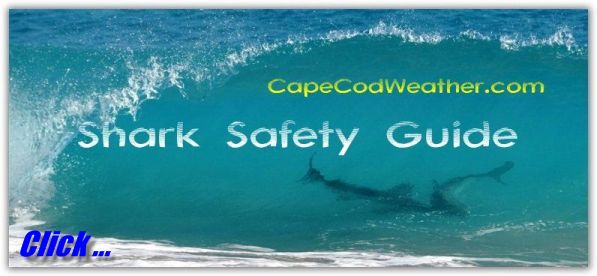
![]() Cape Cod Shark Sightings
Cape Cod Shark Sightings


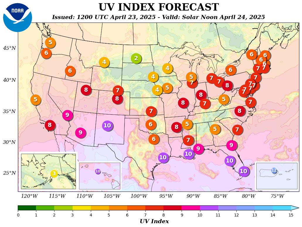
 Daily Ultraviolet Index and UV Forecast Map and UV Alert Map
 Ultraviolet Protection Safety Guide
 Heat Index Chart
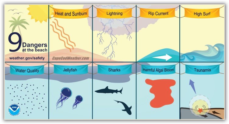
 Ocean Swimming Safety Guide
Average Water Temperatures at Atlantic Coast beaches
90-Day Climate Outlook
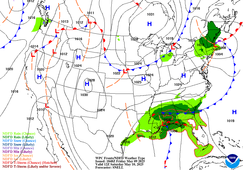
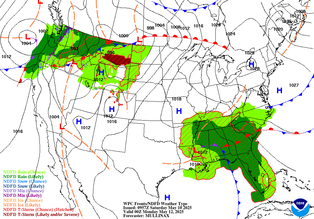
United States Forecast Maps (WPC/NOAA)
Link:
 MA seasonal Pollen Forecast
 Cape & Islands Air Quality Graphic (seasonal)
Massachusetts Air Quality Report/Forecast (seasonal)
Cape & Islands Air Quality Graphic (seasonal)
Massachusetts Air Quality Report/Forecast (seasonal)
 New England Ground Level Ozone Daily Forecast Map (seasonal)
Air Pollution Health Safety Guide
New England Ground Level Ozone Daily Forecast Map (seasonal)
Air Pollution Health Safety Guide
 Massachusetts Drought Monitor Map (USDA/NOAA)
Drought Precautions
Massachusetts Drought Monitor Map (USDA/NOAA)
Drought Precautions
 Sunrise/Sunset
  Moon Phase
  Celestial Almanac
 Official U.S. Time
 New England Marine Forecast Charts (interactive)
 East Coast Tides & Currents
 Tropical Outlook Graphic view of the Atlantic
Strike Probability & Warning Maps (active storms)
Advisories from the National Hurricane Center (interactive)
Latest East Coast Satellite View | Loop
Tropical Outlook Graphic view of the Atlantic
Strike Probability & Warning Maps (active storms)
Advisories from the National Hurricane Center (interactive)
Latest East Coast Satellite View | Loop
 Forecast: 2024 Atlantic Season (NOAA)
  Forecast: 2024 Atlantic Season (CSU)
Storm Surge Information
Atlantic Hurricane Names 2024-2029 (lists)
Retired Atlantic Names 1954-present
Forecast: 2024 Atlantic Season (CSU)
Storm Surge Information
Atlantic Hurricane Names 2024-2029 (lists)
Retired Atlantic Names 1954-present
 24-Hour | 48-Hour | Plain Language
Aviation Weather Data (interactive)
24-Hour | 48-Hour | Plain Language
Aviation Weather Data (interactive)
 New England Ski Resort Conditions (interactive)
 US Daily Snow Monitoring Interactive
![]() Wind Chill Chart
Wind Chill Chart
 Winter Weatherlore
  Groundhog Day (February 2)
 Boston, MA Daily
 Boston, MA Monthly
 Cape & Islands Climate Data:
Chatham | Hyannis | Martha's Vineyard | Nantucket | Orleans | Provincetown
 State-by-State Record High Temperatures
State-by-State Record Low Temperatures
 STORMFAX® Glossary of Weather Words
 Severe Weather Safety Information


in lieu of officially disseminated National Weather Service STATEMENTS, WATCHES and WARNINGS.
 Weather Radio
 Hyannis, MA - 162.550 MHz Boston, MA - 162.475 MHz
NWR-SAME Alert Radios
Dukes County: 025007
Nantucket County: 025019
Plymouth County: 025023

 Cape & Islands Tornadoes: 1950-present U.S. Hurricane Statistics: 1851-present
 Top 25 Strongest Top 25 Deadliest Top 25 Costliest By State By Month By Decade
 Wellfleet Chamber of Commerce
Link:  Cape Cod National Seashore
Link: The Weather of 1620-'21
Link:  Marconi's "Old CC" at South Wellfleet
Link:  Nauset Light Preservation Society


 Please read our Legal Notice and our Privacy Statement.
