


 U.S. Weather News | World Weather News


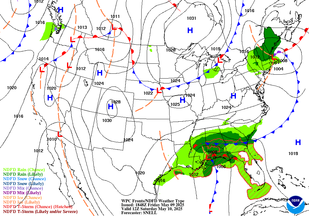
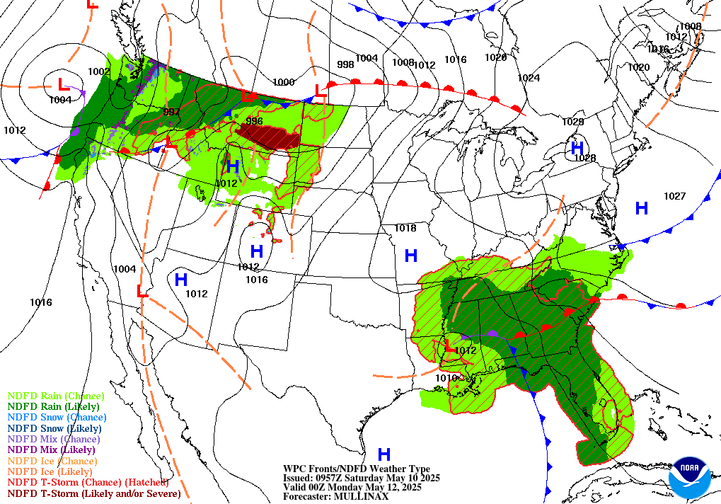
United States Forecast Maps (WPC/NOAA) 24-Hour | 48-Hour | Plain Language
 Canada Weather (interactive)
United States Lightning Strikes (past 60 minutes)
 US Travelers' Cities Weather (list)
 Aviation Weather Data (interactive)
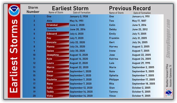
Hurricane Names
 Alaska Weather: Forecasts (interactive) | Radar (interactive)
 Latest Update of Alaska's Redoubt Volcano
 Hawaii Weather: Radar (interactive)
 Bahamas/Caribbean Weather (interactive)
 Bermuda Weather | Radar | WebCam
 European Weather Map | Satellite
European Current Surface Weather (map)
European Extreme Weather
European Weather Map | Satellite
European Current Surface Weather (map)
European Extreme Weather
 Mexico Weather Map | Radar | Satellite

 Today's Jet Stream Map (~160K)
United States Radar (NEXRAD)
Today's Jet Stream Map (~160K)
United States Radar (NEXRAD)
Summary / Precipitation type / Cell movement / Watch boxes
United States Snow Depth maps / Oct-April (interactive)
GOES Satellite Images  US Caribbean
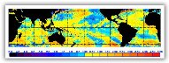
 Global Land/Sea Temperature & Satellite Image
Global Glacier Inventory (interactive)
Global Land/Sea Temperature & Satellite Image
Global Glacier Inventory (interactive)
 Active Atlantic Tropical Cyclones
 QuickCheck for Marine Warnings (text)
Storm Surge Information
QuickCheck for Marine Warnings (text)
Storm Surge Information
![]() US East Coast Significant Wave Heights (OPC)
US East Coast Significant Wave Heights (OPC) 
 Tropical Outlook (list)
Tropical Discussion (list)
Tropical Monthly Summary
Tropical Flooding Reports (interactive)
Tropical Outlook (list)
Tropical Discussion (list)
Tropical Monthly Summary
Tropical Flooding Reports (interactive)
 Inland Flooding Reports
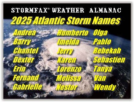
 Forecast: 2025 Atlantic Season (NOAA)
  Forecast: 2025 Atlantic Season (CSU)
Latest U.S. Southeast Coast Satellite View
Saffir-Simpson Category Scale Explained
Forecast: 2025 Atlantic Season (CSU)
Latest U.S. Southeast Coast Satellite View
Saffir-Simpson Category Scale Explained
 Hurricane Archives (interactive)
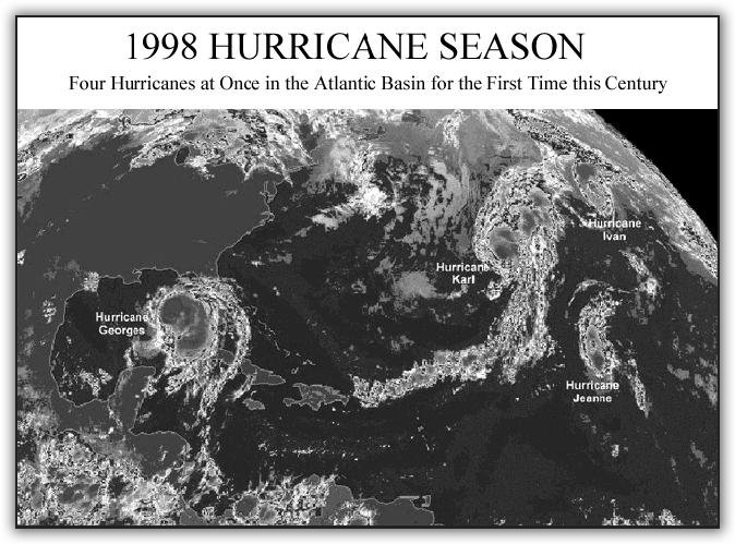
 1998 Atlantic Tropical Cyclone Season Record!
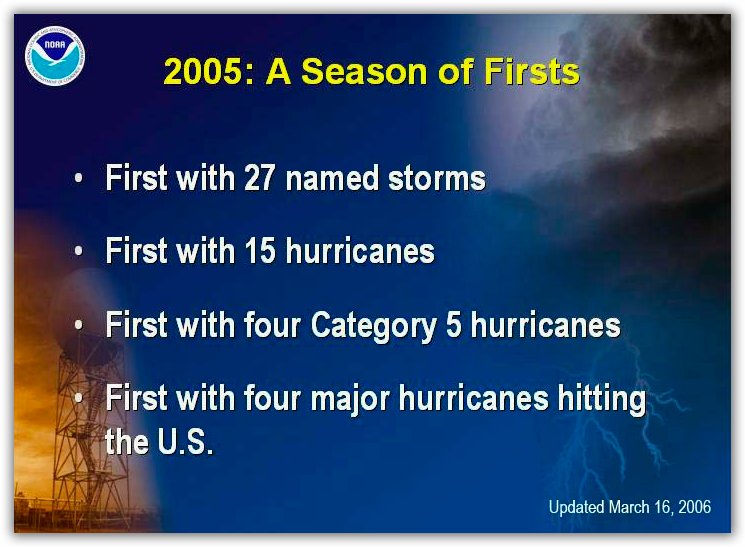
2005 Atlantic Tropical Cyclone Season Record!
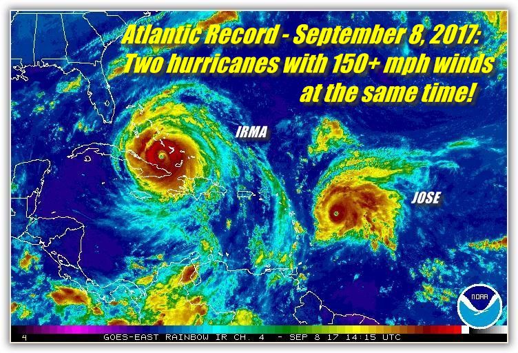
2017 Atlantic Tropical Cyclone Season Record!
2020 Atlantic Tropical Cyclone Season Record! United States Hurricane Statistics (1851-present)
1998 Atlantic Tropical Cyclone Season Record!
2005 Atlantic Tropical Cyclone Season Record!
2017 Atlantic Tropical Cyclone Season Record!
2020 Atlantic Tropical Cyclone Season Record! United States Hurricane Statistics (1851-present)
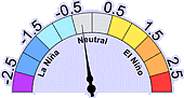
 El Niño / La Niña Advisory
 Sunrise/Sunset
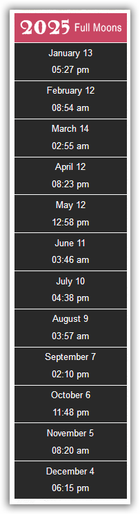
  Moon Phase
  Celestial Almanac
 Official U.S. Time
 NOAA's Space Weather Alerts/Warnings
Geomagnetic storms / Solar Radiation storms / Radio Blackouts
 QuickCheck for latest Solar Alerts/Warnings
Today's Space Weather Data/Forecasts
QuickCheck for latest Solar Alerts/Warnings
Today's Space Weather Data/Forecasts
Solar activity / X-Ray flux / Satellite environment plot
Visit SpaceWeather.com for Current Conditions
 Spaceflight Meteorology / NASA (interactive)
 Extended Forecasts:
 Monthly/Seasonal Climate Outlook
6 to 10-Day Climate Outlook (Text) (Graphic)
30-Day Climate Outlook (Text) (Graphic)
Monthly/Seasonal Climate Outlook
6 to 10-Day Climate Outlook (Text) (Graphic)
30-Day Climate Outlook (Text) (Graphic)
 Autumn Foliage Guide
 Wind Chill Chart
 Winter Weatherlore
 Groundhog Day
 US Daily Snow Monitoring (interactive)
US & International Ski Resort Conditions (interactive)
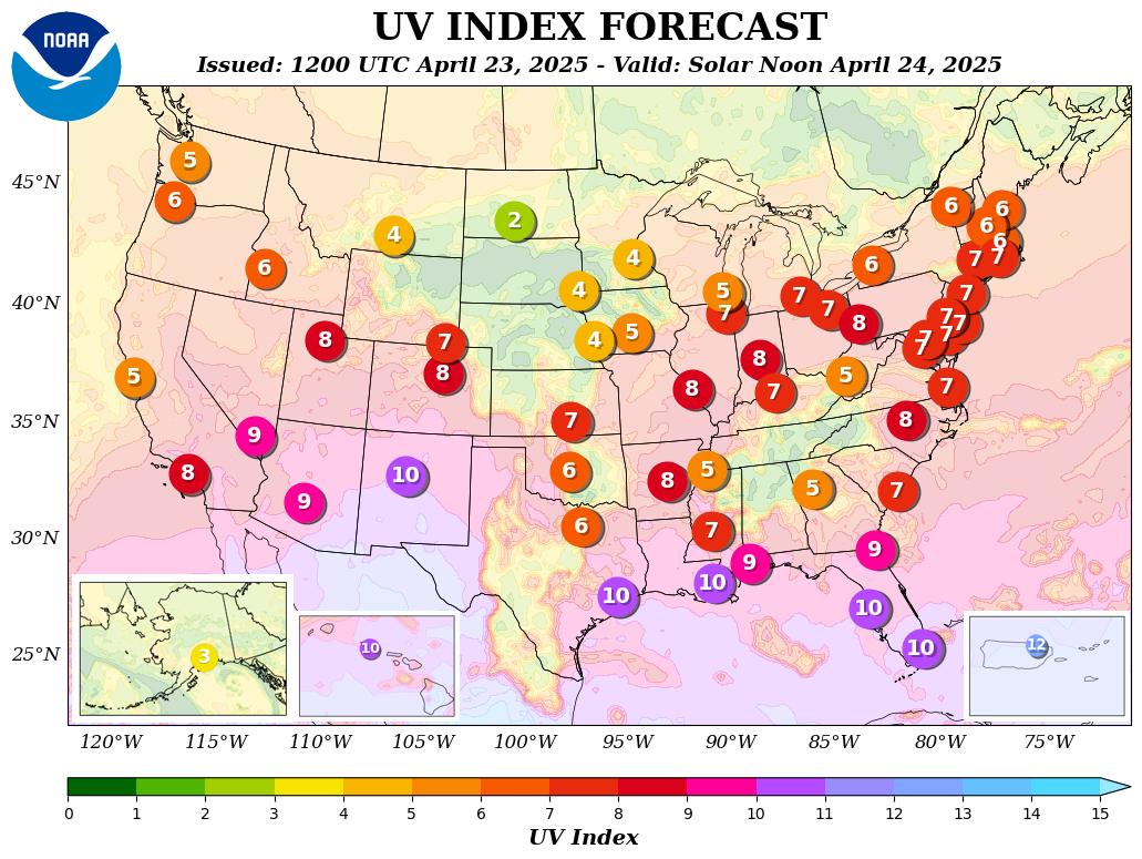
Daily Ultraviolet Index and UV Forecast Map and UV Alert Map
US Daily Snow Monitoring (interactive)
US & International Ski Resort Conditions (interactive)
Daily Ultraviolet Index and UV Forecast Map and UV Alert Map
 Ultraviolet Protection Safety Guide
 Heat Index Chart
 National Air Quality Graphic Forecasts (interactive)
Air Pollution Safety Guide
National Air Quality Graphic Forecasts (interactive)
Air Pollution Safety Guide
 U.S. Drought Portal (NIDIS)
National Drought Monitor Map (USDA/NOAA)
U.S. Drought Portal (NIDIS)
National Drought Monitor Map (USDA/NOAA)
National Drought Forecast Map (NCEP/NOAA)
Drought Precautions
 National Allergy Bureau Pollen Count Information (interactive)
Pollen.Com Pollen Forecast Information (interactive)
National Allergy Bureau Pollen Count Information (interactive)
Pollen.Com Pollen Forecast Information (interactive)
 US Crop Report (NOAA/USDA) Menu | Bulletin
  U.S. Hazard Threats
QuickCheck for latest US/Global Earthquake report (interactive)
Complete List of Active Volcanoes
 Complete List of Global Warming Effects
Meteorological Conversions (tables)
| Contractions | Glossary (interactive)
Complete List of Global Warming Effects
Meteorological Conversions (tables)
| Contractions | Glossary (interactive)
 Severe Weather Safety Information


 Weather Radio
 State/County Codes to program

Daily Weather Archives U.S. Hurricanes: 1900-present 275 U.S. Cities' Monthly Climate Normals U.S. State Record Highs & Lows

 Please read our Legal Notice and our Privacy Statement.


