
1849 1850 1856 1860 1863 1870 1890 1891 1894 1895 1898 1900 1902 1903 1909 1910 1912 1914 1918 1926 1928 1931 1934 1935 1937 1940 1942 1948 1950 1951 1952 1954 1955 1959 1960 1965 1970 1973 1975 1979 1989 1990 1991 1993 1995 1998
 Joseph Henry, Secretary of the Smithsonian Institution, Washington, DC, establishes an extensive weather observation network. 150 observers' data is sent by telegraph.
A daily weather map is posted in the hall of the Institution for public viewing. Corresponding weather "signals" are displayed on the Tower of the Smithsonian castle.
William Ferrel publishes a mathematical model of the circulation of global winds and ocean currents.
600 stations are making regular observations, but communications are interrupted by the Civil War.
Isaac Newton, Commissioner of Agriculture, begins publishing a monthly weather and crop bulletin.
(February 9) President Ulysses S. Grant signs a joint resolution of Congress authorizing the Secretary of War to establish a weather service within the Army.
Joseph Henry, Secretary of the Smithsonian Institution, Washington, DC, establishes an extensive weather observation network. 150 observers' data is sent by telegraph.
A daily weather map is posted in the hall of the Institution for public viewing. Corresponding weather "signals" are displayed on the Tower of the Smithsonian castle.
William Ferrel publishes a mathematical model of the circulation of global winds and ocean currents.
600 stations are making regular observations, but communications are interrupted by the Civil War.
Isaac Newton, Commissioner of Agriculture, begins publishing a monthly weather and crop bulletin.
(February 9) President Ulysses S. Grant signs a joint resolution of Congress authorizing the Secretary of War to establish a weather service within the Army.
1870 (November 1) Simultaneous observations are made at 24 locations by the Army Signal Corps and telegraphed to Washington, DC and other cities and ports.
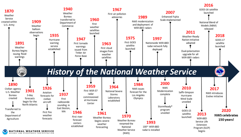
(October 1) At the request of President Benjamin Harrison, Congress creates the U.S. Weather Bureau within the Department of Agriculture. The actual transfer of weather stations, telegraph lines, apparatus, and personnel takes place July 1, 1891.
The Secretary of Agriculture directs the U.S. Weather Bureau to carry out "rain-making" experiments by setting off explosions from balloons in the air.
1891 The U.S. Weather Bureau begins issuing flood warnings.
Weather observations from kites at Harvard's Blue Hill Observatory are established with self-recording thermometers to make observations of temperature aloft.
(September 30) The U.S. Weather Bureau publishes the first daily weather map.
President William McKinley orders the U.S. Weather Bureau to establish a hurricane warning network.
The U.S. Weather Bureau exchanges weather information and warnings with Europe via the transatlantic cable.
The Marconi Company begins sending U.S. Weather Bureau forecasts by wireless telegraphy to steamships of the Cunard Line.
Orville Wright makes the first powered flight after consultation with the U.S. Weather Bureau. By 1904, airplanes were used to conduct upper air atmospheric research.
The U.S. Weather Bureau begins experiments with balloon observations.
The U.S. Weather Bureau begins issuing weekly agricultural forecasts and the River and Flood Division begins drought and moisture assessment of the western U.S.
The U.S. Weather Bureau issues the first fire weather forecast.
The Fire Weather Service is established in 1916.
An Aerological Section is established to service the growing needs of the aviation community.
The U.S. Weather Bureau begins issuing forecasts for domestic military flights and air mail routes.
The Air Commerce Act directs the U.S. Weather Bureau to provide for weather services to civilian aviation.
Teletype replaces the telegraph for weather communications.
Regular aircraft observations begin at Chicago, Cleveland, Dallas and Omaha. Altitudes reaching 16,000 feet are met and the kite service ends.
The U.S. Weather Bureau establishes the Air Mass Analysis Section.
In 1917, Norwegian meteorologists pioneered air mass analysis which dramatically improved forecasting accuracy.
The U.S. Weather Bureau begins collecting marine weather data from automatic instruments on floating buoys.
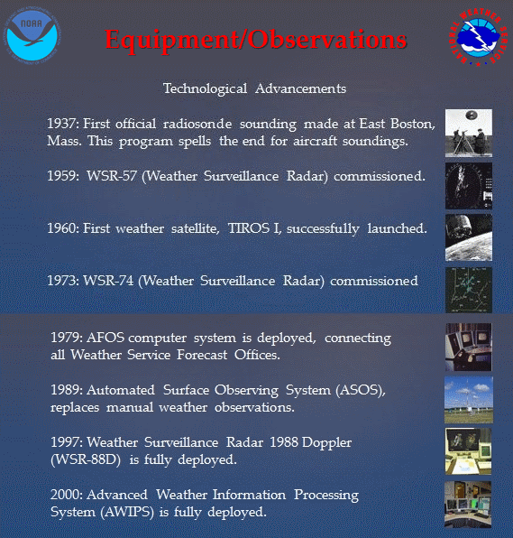
The first official U.S. Weather Bureau radio meteorograph or "radiosonde" soundings are made at East Boston, MA. This program ends aircraft soundings because balloons can reach heights of 50,000 feet.
(June 30) The U.S. Weather Bureau is transferred to the Department of Commerce.
The Navy gives the U.S. Weather Bureau 25 surplus aircraft radars to be modified for ground meteorological use.
The first primitive computer numerical forecasts are made on the Electronic Numerical Integrator and Computer (ENIAC).
1948 USAF Air Weather Service meteorologists issue the first tornado warnings for military installations.
The U.S. Weather Bureau begins issuing 30-day outlooks to the public.
The Weather Service Warning Center begins operations at Tinker Air Force Base, OK. This is a forerunner of the National Severe Storms Center (NSSC).
The U.S. Weather Bureau organizes the Severe Local Storm Forecasting Unit in Washington, DC and begins issuing tornado forecasts. The Unit moves to Kansas City, Missouri in 1954.
The first radar specifically designed for meteorological use, the AN/CPS-9, is unveiled by the Air Weather Service, USAF.
The U.S. Weather Bureau begins development of the Barotropic model, which will become the first operational numerical weather prediction tool.
The first WSR-57 weather surveillance radar is commissioned at the Miami hurricane forecast center. The same model remained in service across much of the nation until replacement by the 88D Doppler radar.
(April 1) TIROS 1, the world's first weather satellite is launched.
1960 U.S. Weather Bureau meteorologists issue the first advisories on air pollution over the eastern United States.
The Environmental Science Services Administration (ESSA) is created within the Department of Commerce, incorporating the U.S. Weather Bureau and several other agencies.
ESSA becomes the National Oceanic and Atmospheric Administration (NOAA) and the U.S. Weather Bureau is renamed the National Weather Service under NOAA.
The National Weather Service purchases its second generation radar, the WSR-74C.
The first geostationary weather satellite GOES 1 is launched.
The NGM (Nested Grid Model) becomes operational. The AFOS (Automation of Field Operations and Services) computer system is deployed connecting weather offices and replacing teletype.
The National Weather Service embarks on a national modernization plan with restructuring of the entire organization.
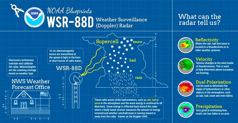
The contract for the WSR-88D radar is awarded. The new Doppler technology permits weather forecasters to see the movement of rain and winds within storms and to more accurately identify tornado formation.
The first WSR-88D radar is installed in Melbourne, Florida.
1991 The contract for the ASOS systems is awarded.
The contract for the Advanced Weather Interactive Processing System (AWIPS) computer system is awarded.
NOAA Weather Radio begins broadcasting coded emergency weather signals (watches, warnings and statements) that identify the specific geographic NWS area affected by the emergency. This technology is called S-A-M-E [Specific Area Message Encoding] and permits the public to select receiving only "alerts" that apply to their county or region.
The final NEXRAD WSR-88D radar is commissioned in North Webster, Indiana, bringing the network to 120 units.
2000 The Advanced Weather Interactive Processing System (AWIPS) is commissioned. It allows assimilation of radar, satellite, surface and upper air observations, and computer model guidance into one workstation. The older AFOS system is decommissioned.
2013  The dual-polarization (both horizontal and vertical) technology upgrade is completed at the 122nd NWS NEXRAD Doppler network site in the US. Begun in September 2011, the update to more accurately tracks, assesses, and warns the public of approaching high-impact weather.
 STORMFAX®
 Please read our Legal Notice and our Privacy Statement.